CHAPTER I
INTRODUCTION
1.1 Background of Study
In our daily live, all people have to maintain to their environment. Environment is an object of study by people. People can learn about their nature or furthermore, people are able to understand of the symptom of this nature. For instance, have you remember of tsunami that has disturbed Aceh province last years ago? Have you remember the earthquake which has disturbed Yogja province last years ago? Have you remember about the eruption of Agung mountain volcano last years ago? The last, have you think why the surface of the earth isn’t flat? These all of the natural disaster which have to analyzed.
The interesting phenomenon such as volcanic activity is the most powerful force in nature. Some volcanic eruptions are much more powerful than the largest nuclear explosion. Volcanoes have killed thousands of people and have created some of the most frightening events in human history. Volcanoes have been the basis for myths and legends the world over. Volcanoes are also responsible for much of the land we live on, 90% of all the continents and ocean basins are the product of volcanism. The air we breathe, and the water we drink have been produced by millions of years of eruptions of steam and other gases (adapted from http://volcano.und.nodak.edu/vw.html).
Like wise to volcano, earthquake is the same interesting phenomenon of the nature. Actually, all of them can be learned deeply regarding to the scientific study that has done by the scientist. Volcano and earthquake are the example of natural symptom which cause by the endogenous power of earth. There are two kinds of geological power, as follows endogenous and exogenous. Endogenous power is power addressed from the inside of earth. While, exogenous power is addressed from outside of earth (adapted from Pujani, 2004: 10). Both of the earth power are able to cause the surface of earth isn’t flat.
In this discussion we are going to investigate about the endogenous and exogenous power, but with emphasis on the detailed of volcanic, earthquake, weathering, mass wasting, precipitation of soil, landform, and the structure of the earth’s surface. Furthermore discussion, we are going to analyze the geologic processes of them. Therefore, here we examine these matters using scientific approach, actually geological physics approach.
1.2 Statement of Problems
Actually, the discussion of this study has emphasized detailed of volcanic, earthquake, weathering, mass wasting, and precipitation of soil, landform, and the structure of the earth’s surface. But the most important case is how all of these matters can be explain regarding to the geological physics approach. Therefore, it needs for us to describe all of process base on this approach.
1.3 Purpose of Study
The main purpose of this study is to analyze the natural phenomenon of earth, such as geological symptom that cause by the geological power i.e., exogenous and endogenous power. Specifically, it is to explain this entire phenomenon using geological physics approach.
1.4 Significant of Study
Regarding to this study, we are able to understand about the geological symptom. We are able to explain how does the geological symptom i.e., volcano, earthquake, mass wasting, landform, and the other matter can be happen. We also able to analyze this process using geological physics approach, is a scientific method based on physics and geology concept.
CHAPTER II
VOLCANOES AND TECTONIC LANDFORM
2.1 Volcanoes
2.1.1 General Description of Volcanoes
Volcanoes are conical or dome-shaped structures built by the emission of lava and its contained gases from a constricted vent in the earth’s surface. The magma rises in narrow, pipelike conduit from a magma reservoir lying beneath. Reaching the surface, igneous material may pour out in tongue like lava flows or may be ejected under pressure of confined gases as solid fragment. Ejected solid fragment ranging in size from gravel and down to fine sild size are collectively called tephra. Form and dimension of a volcano are quited varied, depending on the type of lava and the present or absent of tephra. The nature of volcanic eruption, whether explosive or quiet, depends on the type of magma. The important point is that the felsic lavas (rhyholite and andesit) have high degree of viscosity (property of tackiness, resisting flowage) and hold large amount of gases under pressure. As a result, these lavas produce explosive eruptions. In contrast, mafic lava (basalt) is highly fluid (low viscosity) and hold little gas, with the result that eruptions are usually quiet and the lava can travel long distances to spread out in thin layer.
Scientifically, the type of volcano can be cause by any factor beside its explosive, the form and the location of magma chamber took place also. Generally, for the deep of magma chamber is able to make larger explosive than the shallow one. The areas of magma chamber can influent the time that need by volcano to do its activity.
Magma is a complex mixture of liquid, solid, and gas. The main elements in magma are oxygen (O), silicon (Si), aluminum (Al), calcium (Ca), sodium (Na), potassium (K), iron (Fe), and magnesium (Mg). However, it is two major molecules found in magma that controls the properties of the magma. These two molecules are silica (SiO2) and water (H2O). Silica comprises as much as 75 percent of the magma.
When rock melts deep underground, the magma rises through the earth's crust because the molten rock is less dense than solid rock. In many cases, the magma is unable to reach the surface, and it will cool in place many miles under the ground. This underground cooling produces the largest crystal sizes, because it cools more slowly. Sometimes the magma extrudes onto the surface, either on land or underwater. Magma which comes to the surface is called lava.
Much of the magma that rises from the mantle comes from subduction zones, where oceanic crust dives beneath continental crust. Magma also rises to the surface under what is known as "hot spots." These are areas of volcanic activity that are not related to subduction zones (adapted from http://www.answersincreation.org/index.htm)
When magma took up to the top of volcano, it is not usually to reach the surface of earth. It is caused by the force that push it to the up of the volcano is still lack. This magma just take place in the layer of rock, probably, this magma is able to be metamorphic rock and igneous rock. The process when magma brought up in the layer of rock and do not reach the surface of earth is called plutonic (magma intrusive). An intrusion is liquid rock that forms under the surface of the earth. Magma from under the surface slowly moves its way up from deep within the earth and moves into any cracks or spaces it can find, sometimes pushing existing country rock out of the way, a process that can take millions of years or more to form. As the rock slowly cools into a solid, the different parts of the magma slowly crystallize into minerals. The more slowly the crystals form, the larger the crystals can get. Volcanic rock, by contrast, cools very quickly on the surface of the earth, and thus, generally have only microscopic crystals, such as in an ash cloud (whose crystals are tiny dust particles) (adapted from http://en.wikipedia.org/wiki/Intrusion).

Figure 1. The structure of volcanoes
(Adapted from http://en.wikipedia.org/wiki/Extrusive)
Intrusions are one of two ways for igneous rock to form; the other way is extrusive, that is, a volcano eruption or similar event. Technically speaking, an intrusion is any formation of intrusive igneous rock; rock formed from magma that cools and solidifies within the crust of a planet. In contrast, an extrusion consists of extrusive rock; rock formed above the surface of the crust.
Intrusions vary widely, from mountain range sized batholiths to thin vein-like fracture fillings of aplite or pegmatite. When exposed by erosion, these cores called batholiths may occupy huge areas of Earth's surface. Large bodies of magma that solidify underground before they reach the surface of the crust are called plutons.
Other reference point out that, magma that solidifies below the earth’s surface and is surrounded by older, preexisting rock called intrusive igneous rock. There are several distinctive rock formations that are formed from intrusive igneous rocks (adapted from http://en.wikipedia.org/wiki/Intrusion).
1. Batholiths are very large bodies of crystalline rocks, typically composed of granite. They are the largest rock bodies in the earth's crust, and they can cover several thousand square kilometers.
2. Stocks are essentially small batholiths, less than 100 square kilometers. Stocks are important because many deposits of silver, gold, and other metals have been found in veins extending from a stock into the surrounding rock.
3. A dike is a narrow, tabular body of igneous rock. It forms where magma squeezes into fractures in the surrounding rock and cools. The width of a dike can range from inches to hundreds of feet, and the length of a dike can be several hundred miles.
4. A sill is a tabular intrusive layer of rock that is parallel, or concordant to, the layering. In the diagram at right, you can see that the sills are parallel to the layered rock beds, whereas the dikes are perpendicular to them. Why would a sill form? Rising magma follows the path of least resistance. If the magma can no longer rise, then the path of least resistance may take it laterally in between the rock layers. Sills are typically from mafic magmas, as the felsic magmas are not as fluid. The term geologists use to describe a liquid's ability to flow is called viscous. Mafic magmas are less viscous than felsic magmas. Substances with high viscosity have a high resistance to flow. Sills commonly have inclusions, which are blocks and pieces of the surrounding rocks embedded in the igneous material of the sill.
5. A laccolith is an intrusive rock body that begins as a sill, as material fills in between rock layers. Because of the pressure, some sills can arch up the overlying sediments, creating a lens-shaped rock body, with a flat bottom, but curved at the top. Laccoliths tend to form at shallow depths.
Extrusive refers to the mode of igneous volcanic rock formation in which hot magma from inside the Earth flows out (extrudes) onto the surface as lava or explodes violently into the atmosphere to fall back as pyroclastics or tuff. This is opposed to intrusive rock formation, in which magma does not reach the surface.
The main effect of extrusion is that the magma can cool much more quickly in the open air or under seawater, and there is little time for the growth of crystals. Often, a residual portion of the matrix fails to crystallize at all, instead becoming an interstitial natural glass or obsidian. If the magma contains abundant volatile components which are released as free gas, then it may cool with large or small vesicles (bubble-shaped cavities) such as in pumice, scoria, or vesicular basalt (adapted from http://en.wikipedia.org/wiki/Extrusive)
When magma take up to the earth surface, it will be produces any materials, such as volcanic material. Generally, it can be classified into two kinds, such as liquid material and solid material. For instance, liquid material can be formed, such as lavas, volcanic mudflow, and rain flow volcanic. Lava is magma that has been molten at the earth’s surface. Volcanic land flow is dripping of hot mud which due to magma that has been mixed with water; the water comes from crater lake. While, rain flows volcanic is dripping of mud which happen from eflata that has washed away by flowing of rain on the slope of mountain.
Solid materials that produce are volcanic bomb, lapillus, sand, and dust. Volcanic bomb can damage because it can produce big lava rock that taken up with high power. Lapillus is small lava rock. The last material is gas. Gas that produced from magma is called exhales; it is consist of carbon dioxide (CO2), sulfur acid (H2S), nitrogen, and water vapor (H2O). Deeply, the area of volcanic where magma has carried out is called cauldron. The bigger one is called caldera.
Why does the explosion of volcanic occur? Fundamentally, the explosion of volcanic is able causes by the process of heat inside of the earth. This heat is produced by the explosion of radioactive material such as uranium and thorium which hold in almost of rocks inside the earth. The heat that emitted is able to liquefy rocks into magma. Magma is a silicate solution with sulfide and oxide, which consist of any gases. In this process, the weight of liquid rocks becomes smaller than the weight of solid rock, where surrounding of them. Furthermore, the solute gases cause the rock smaller in weigh.
Magma is pressed by bigger rocks on its surrounding and be push up through eruption and interruption. The speed of lava comes out of the earth rarely bigger. But the magnitude of this speed depend to the viscosity of lava and the magnitude of soil inclination that through by them. The surface of lava after they have freezed depends to its chemical impurities and the characteristic of its flows.
Furthermore, the volcanic can be detected by considered some of important role below:
1. there is big thundering form inside of the earth,
2. there is small earthquake,
3. the temperature of soil tends to increase. Actually, the temperature of water is able to increase too,
4. plants around the crater tend to die, and
5. almost all of animals around the volcano be scare and move uncertainty.
After volcanic happened, it is rarely to show the volcanic symptom, although it is not too dangerous. This symptom can be known from the sign below.
1. Exhales : magma gases that carried out from the slot of the crater and its surrounding, such as:
ü Fumaroles : this produces warm water,
ü Sulfates : this produces sulfide vapor,
ü Mofet : this produces carbon dioxide.
2. Mineral water usually called thermen, because the water tends to warm.
3. Geyser, warm water resources that can carry out of warm water unperiodically.
2.1.2 Types of Volcanoes
In the surroundings of boundaries of tectonic plates the following types of volcanoes occur: The fissure volcano is a long crack in the earth's surface through which magma erupts. (adapted from http://mediatheek.thinkquest.fullvolcano.htm). This crack may form as two tectonic plates pull apart. The ordinary volcanoes can be divided indifferent types, relating to their forms:
1. The shield volcano: this is a broad, shallow volcanic cone, which arises because the running lava, which is fluid and hot, cools slowly.
2. The dome volcano: This one has a steep, convex slope from thick, fast-cooling lava.
3. The ash-cinder volcano: Throws out - besides lava - much ash into the air. Through this the volcanic cone is built up from alternate layers of ash and cinder.
4. The composite volcano: These are also built up from alternate layers of lava and ash but, besides its main crater, it has many little craters on its slope.
5. The caldera volcano: An older volcano with a large crater which can be 62 miles (100 km) wide. In this crater many little new craters are formed.

Figure 2. The type of volcanic
2.1.3 Volcanic Eruption as an Environmental Hazard
The eruption of volcanoes and lava flows are environmental hazard of severest sort, often taking a heavy toll of plant and animal life and devastating human habitations. Wholesale loss of life and destruction of towns and cities are frequent in history of peoples who live near active volcanoes. Loss occur principally from sweeping clouds of incandescent gases that descend the volcano slope like great avalanches; from lava flows whom relentless advance engulfs whole cities; from the descent of showers of ash, cinder, and bombs; from violent earthquake associated with volcanic activity; and from mudflows of volcanic ash saturated by heavy rain. For habitations along low-lying coasts there is the additional peril of great seismic sea wave, generated elsewhere by explosive destruction of volcanoes.
Despite their potential for destructive activity, volcanoes are valuable natural resources in term of recreation and tourism. Few landscapes can rival in beauty the mountainous landscape of volcanic origin.
2.2 Earthquake
An earthquake is a motion of the ground surface, ranging from a faint tremor to a wild motion capable of shaking building apart. The earthquake is a form of energy of wave motion transmitted through the surface layer of the earth in widening circles from a point of sudden energy release-the focus. Like ripples produced when a pebble is thrown into a quiet pond, these seismic waves travel outward in all directions, gradually losing energy. Earthquake is produced by sudden movements along faults; commonly these are normal faults or transcurrent faults (adapted from Athur, 1918: 254).
We will not go into the details of mechanics of faults and how the produces earthquakes. It must be enough to say that rocks on both sides of the fault is slowly bent over many years as tectonic forces are applied in the movement of large crustal masses. Energy accumulates in the bent rock, just as it does in a bent crossbow. When critical point is reached, the strain is relieved by slippage on the fault and large quantity of energy is instanneously released in the form of seismic waves. Slow bending of the rock takes place over many decades. Its release then causes offsetting of features that formerly crossed the fault in straight lines, for example, a roadway or fance. Faults of this type can also show a slow, steady displacement known as fault creep, which tends to reduce the accumulation of stored energy.

Figure 3. Plate tectonic sympton as a cause of earthquake
The Richter scale of earthquake magnitudes was devised in 1935 by the distinguished seismologist, Charles F Richter, to indicate the quantity of energy released by a single earthquake. Scale numbers from 0 to over 9.0, but there is no upper limit except for nature’s own limit of energy release (adapted from Athur, 1918: 255).
2.2.1 Earthquake and Plate Tectonics
Seismic activity, the repeated occurrence of earthquakes. The greatest intensity of seismic activity is found along converging plate boundaries where oceanic plates are undergoing subduction. Strong pressures build up at the down slating contact of the two plates, and these are reliable by sudden fault slippages that generate earthquake of large magnitude. Transform boundaries that cut through the continental lithosphere are sites of intense seismic activity, with moderate to strong earthquakes (adapted from Athur, 1918: 255).
Spreading boundaries are a third class of narrow zones of seismic activity related to lithosphere plates. Most of these boundaries are indentified with mid-oceanic ridge ad its branch. Earthquake are generated both along the ridge axis and on the transform faults that connect offset end of the ridge. but they are mostly small earthquakes set of ar shallow
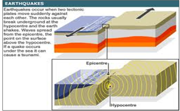
Figure 4. The radiation of earthquake’ wave
Earthquake also occurs at scattered locations over the continental plates, far from the active plates boundaries. In many cases, no active faults are visible and the geologic cause of earthquakes of southern Asia is probably related to the continental suture between the Eurasian plate and the Arabian and Austral-Indian plates.
2.2.2 Earthquakes as an Environmental Hazard
An important environmental hazard associated with a major earthquake is the seismic sea wave, or tsunami. A train of these water waves is often generated in the ocean at a point near the earthquake sources by a sudden movement of the seafloor. The wave travel ever the ocean in ever-widening circles, but they are not perceptible at sea in the deep water. When a wave arrives at a distant coastline, the effect is to cause a rise of water level. Wind-driven waves, superimposed on the heightened water level, allow the surf to attack plates inland that are normally above the reach of waves.
2.3 The Exogenous Power of Earth
2.3.1 Weathering
Weathering is the general term applied to the combine action of all processes causing rock to be disintegrated physically and decomposed chemically because of exposure at or near the earth’s surface. The products of rock weathering tend to accumulate in soft surface layer, called regolith. The regolith grades downward into solid, unaltered rock, known simply as bedrock. Regolith, in turn, provides the sources for sediment consisting of detached mineral particles transported and deposited in a fluid medium. Which may be water, air, or glacial ice? Both regolith and sediment comprise parent material for the formation of the true soil, a surface layer capable of supporting the growth of plants (adapted from Athur, 1918: 259).
Weathering also plays a major role in denudation. Disintegration and decomposition of various kinds of hard bedrock greatly facilitate the erosion of the land surface by running water. Beside this function, weathering leads to a number of distinctive landform.
In addition to the chemical and physical change in mineral matter that results from weathering, there is a continued agitation in the soil and regolith because of change in temperature and water content. These daily and seasonal rhythms of change continue endlessly.
The spontaneous downhill movement of soil, regolith and rock under the influence of gravity is included under the general term mass wasting. All process of the life layer take place in the earth’s gravity field and all particles of matter tend to respond to gravity. Movement to lower levels take place when the internal strength of mass of soil or rock declines to a critical point below which the force of gravity cannot be resisted. This failure of strength under the ever-present force of gravity takes many forms and scales.
2.3.1.1 Physical Weathering
Physical weathering produces fine particles form massive rock by the action of forces strong enough to fracture the rock. One of the most important physical weathering processes in cold climates is frost action, the repeated growth and melting of ice crystals in the pore spaces of soil and in rock fracture. Frost action is believed to be capable of rupturing even extremely hard rocks. Frost action produces a number of conspicuous effects and form in all climates with cold winters. Features caused by ground-ice accumulation and frost action are particularly conspicuous in the tundra climate of arctic coastal fringes and islands, and above timberline in high mountains.
Frost shattering of hard rock exposed above timberline leads to surface accumulations of large angular fragments, including huge boulders. Frost action on cliffs of bar rock in high mountains detaches rock fragments that fall to the cliff base. Where production of fragment is rapid, they accumulate to form talus slopes. Most cliffs are notched by narrow ravines that funnel the fragment into separate tracks, so as to produce cone like talus bodies arranged side by side along the cliff. Fresh talus slopes are unstable, so that the disturbance created by walking across the slop or dropping a large rock fragment from the cliff above will easily set off a sliding of the surface layer of particles.

Figure 5. The structure of wind as a physical weathering
Closely related to the growth of ice crystal is the weathering process of rock disintegration by growth of salt crystals. This process operates extensively in dry climates and is responsible for many of the niches, shallow caves, rock arches, and pits seen in sandstone formations. During long drought periods, ground water is drowning to the surface of the rock by capillary force. As evaporation, of the water takes places in the porous outer zone of the sandstone, tiny crystals of salts are left behind. The growth force of these crystals is capable of producing grain-by-grain breakup of the sand stone, which crumbles into a sand and is swept away by wind and rain. Especially susceptible are zones of rock lying close to the base of a cliff, because there the ground water seeps outward to reach the rock surface (adapted from Athur, 1918: 260-263).
2.3.1.2 Form Produces by Chemical Weathering
Recall that the dominant processes of chemical change affecting silicate minerals are oxidations, carbonic acid action, and hydrolysis feldspar and the mafic minerals are very susceptible to chemical decay. On the other hand, quartz is a highly stable mineral, almost immune to decay.
Decomposition by hydrolysis and oxidation change strong rock into very weak regolith. This change allows erosion to operate with great effectiveness, whenever the regolith is exposed. Weakness of the regolith is also makes it susceptible to natural forms of mass wasting.
In warm, humid climates of the equatorial, tropical and subtropical zone hydrolysis and oxidation often result in decay of igneous and metamorphic rock to depths as 100 m (300 ft). To the civil engineer, deeply weathered is of major importance in constructing highways, dams, or other heavy structures. Although the regolith is soft and can be removed by power shovels with little blasting, there is serious danger of failure of foundations under heavy loads. This regolith also has undesirable plastic properties because of a high content of clay minerals.
The hydrolysis of exposed granite surfaces is accompanied by the grain-by-grain breakup of the rock. This process creates many interesting boulder and pinnacle from by rounding of angular joint blocks. These forms are particularly conspicuous in arid region. There is ample moisture in most deserts for hydrolysis to act, given sufficient time. The products of grain-by-grain breakup form coarse desert gravel, which consist largely of squats and partially decomposed feldspars (adapted from Athur, 1918: 264).
2.3.1.3 Organic Weathering
Plant and animal can makes the surface of the earth be weathered. This weathering usually cause by the habit of animal or the growing of plant’s root. Actually, this growing of plant’s root and the habit of animal are damage to the surface of earth. For instance, the weathering of the rock that cause by fish on the floor of sea, weathering of soil that cuses by the growing of plant’s root, what else spread around the earth surface.
2.3.2 Mass Wasting
Everywhere on the earth’s surface, gravity pulls continually downward on all materials. A bedrock is usually so strong well supported that it remains fixed in place but, where a mountain slope become too steep, bedrock masses break free, falling or sliding to a new positions of rest. In case where huge masses of bedrock are involve, the result can be catastrophic in loss to life and property in towns and villages in the path of the slide. Such slide is a major form of an environmental hazard in mountainous regions. Because soil, regolith, and many form of sediment are held together poorly, they are much more susceptible to the force of gravity than is bedrock. Abundant evidence show that on most slopes at least a small amount of downhill movement is going on constantly. Although much of this motion is imperceptible, the regolith sometimes slides or flows rapidly.
Taken altogether, the various kinds of downhill movements occurring under the pull of gravity, collectively called mass wasting, constitute an important process in lowering the continental surfaces. Humans have added to the natural forms of mass wasting by moving enormous volumes of rock and soil on construction site of dams, canal, highways, and buildings (adapted from Athur, 1918: 266).
2.3.2.1 Fluvial Processes and Landform
Landform shaped by running water are conveniently describe as fluvial landforms to distinguish them from landforms made by the other fluid agents-glacial ice, wind, and waves. Fluvial landforms are shaped by the fluvial processes of overland flow and stream flow. Weathering and the slower forms of mass wasting, such as soil creep, operate hand in hand with overland flow, and cannot be separated from the fluvial processes.
Fluvial landforms and fluvial processes dominate the continental land surface the world over. Throughout geologic history, glacial ice has been present only in comparatively small global areas located in the polar zones and in high mountains. Landforms made by wind action occupy only trivially small part of the continental surfaces, while landforms made by waves and currents are restricted to a very narrow contact zone between oceans and continents. In term of area, the fluvial landforms are dominant in the environment of terrestrial life and are the major sources areas of human food resources through the practice of agriculture. Almost all lands in crop cultivation and almost all grazing lands have been shaped by fluvial processes.
Figure 6. The fluvial process
Fluvial processes perform the geological activities or erosion, transportation, and deposition. Consequently, there are two major groups of fluvial landform i.e., erosion landforms and depositional landforms. Valleys are formed where rock is eroded away by fluvial agents. Between the valleys are ridges, hills, or mountain summit representing unconsumed part of the crustal block. All such sequential landforms shaped by progressive removal of the bedrock mass are erosion landforms.
Fragments of soil, regolith, and bedrock that are removed from the parent mass are transported by the fluid agent and deposited elsewhere to make an entirely different set of surface features, the depositional landforms (adapted from Athur, 1918: 275).
2.3.2.2 Landforms Made by Waves and Wind
a. Wave Erosion
Wave travel across the deep ocean with little loss of energy. When wave reach shallow water, the drag of the bottom slows and steepens the wave until it leaps forward and collapses as a breaker. Many ton of water surge forward, riding up the beach slope. Where a cliff lies within reach of the moving water, it is impacted with enormous force. Rock fragment of all sizes, from sand to cobbles, are carried by the surging water and thrust against bedrock of the cliff. The impact breaks away new rock fragments and the cliff is undercut at the base.
As the sea cliff retreats landward, continued wave abrasion forms a abrasion platform. This sloping rock floor continues to be eroded and widened by abrasion beneath the breakers. If a beach is present, it is little more than a thin layer of gravel and cobblestones.
Sea cliff is feature of spectacular beauty as well as habitats for many forms of life, including sea mammals and shore birds. Only in recent years has the need to preserve these coiffed coast in their natural stated been fully appreciated. Although the strength of these rocky features resist alteration, the cliff line is vulnerable to heavy use for summer homes, motels, and restaurants. Intensive use not only destroys the pristine scenery, but it also adds pollution (adapted from Athur, 1918: 321-322).
b. Beaches
Where sand is in abundant supply, it accumulates as a thick, wedge-shaped deposit, or beach. Beaches absorb the energy of breaking waves. During short period of storm, the beach is cut back, but the sand is restored during long periods when waves are weak. In this way a beach may retain a stable configuration, or equilibrium state, over many years’ time.
Beaches are shaped by alternate landward and seaward currents of water generated by breaking waves. After a breaker has collapsed a foamy, turbulent sheet of water rides up the beach slope. This swash is powerful surge causing a landward movement of sand and gravel on the beach. When the force of the swash has been spent against the slope of the beach, a return flow, or backwash, pour down the beach. Sands and gravels are seaward by the backwash. Surf bather are familiar with the backwash as a strong backward current felt in the breaker zone. This “undercurrent” or “undertow”, as it is popularly called, can be strong enough to sweep unwary bathers off their feet and carry them seaward beneath the next oncoming breaker (adapted from Athur, 1918: 322).
c. Littoral Drift
The unceasing shifting of beach materials with swash and backwash of breaking waves also results in sidewise movement known as beach drift. Wave front usually approaches the shore obliquely rather than directly head on. The swash rides obliquely up the beach, and the sand is move obliquely up the slope. After the water has spent its energy, the backwash flows down the slope of the beach in the most direct downhill direction. The particles are dragged directly seaward and come to rest at a position in to one side of the starting place. On a particular day, waves fronts approach consistently form the same direction, so that this movement is repeated many times. Individual rock particles travel long distance along the shore. Multiplied many thousands of times to include the numberless particles of the beach, beach drift becomes a leading form of sediment transport.
When waves approach a shoreline under the influence of strong winds, the water level is slightly raised near shore by a slow shoreward drift of water. The excess water pushed shoreward must escape. A long shore current is set up parallel to shore in a direction away from the wind. When wave and wind are favorable, this current is capable of moving along the sea bottom in a direction parallel to the shore. The process is called long shore drift.
Both beach drift and long shore drift moves particle in the same direction for a given set of onshore winds, and they supplement each other’s influence. The total process is called littoral drift.
Littoral drift operate to shape shorelines in two quite different situations. Where the shoreline is straight or broadly curved for many kilometers at a stretch, littoral drift moves the sand along the beach in one direction for a given set of prevailing winds (adapted from Athur, 1918: 323).
d. Wind Action
Wind blowing over the solid surface of the land is one of the lands is one of the active agent of landform development. Ordinarily, wind is not strong enough to dislodge minerals matter from the surfaces of tightly knit rock or of moist, clay-rich soils, or of soils bound by a dense plant cover. Instead, the action of wind in eroding and transporting sediment is limited to land surface where small mineral and organic particles are in the loose state. Such areas are typically desert and semiarid land. An exception is the coastal environment, where beaches provide abundant supplies of loose sand, even where the climate is humid the land surface inland from the coast is well protected by a plant cover.
Landform shaped and sustained by wind erosion and deposition represent distinctive life environments, often highly specialized with respect to the communities of animals and plants they support. Climates with barely sufficient soil water, there is a contest between wind action and the growth of plants that tend to stabilized landforms and protect them from wind action. We will find precarious balances in the life systems of certain marginal climatic zones. These balances are not only altered by natural change in climate, but are easily upset by human activities, and often with serious consequences. To understand these environmental changes, we need to acquire a working knowledge of the physical process of wind action on the land surface (adapted from Athur, 1918: 255).
e. Erosion by Wind
Wind performs two kinds of erosion work. Loose particles lying on the ground surface may be lifted into the air or rolled along the ground. This process is deflation. Where the wind drives sand and dust particles against an exposed rock or soil surface, causing it to be worn away by the impact of the particles, the process is wind abrasion. Abrasion requires cutting tools carried by the wind; deflation is accomplished by air current alone.

Figure 8. A Landform made by wind
A landform produced by deflation is a shallow depression called a blowout. This depression may be from a few meters to a kilometer or more in diameter, but it is usually only a few meters deep. Blowouts form in plains regions in dry climates. Any small depression in the surface of the plain, particularly when the grass cover is broken through, mat develops into a blowout. Rains fill the depression, creating a shallow pond or lake. As the water evaporates, the mud bottom dries out and cracks, forming small scales or pellets of dried mud that are lifted out by the wind. In grazing lands, animals trample the margins of the depression into a mass of mud, breaking down the protective grass-root structure and facilitating removal when dry. Blowouts are also found on rock surface where the rock is being disintegrated by weathering (adapted from Athur, 1918: 340).
2.3.2.3 Glacial Landforms and the Ice Age
a. Glacial Erosion
Glacial is usually heavily charged with rock fragments, ranging from pulverized rock flour to Hugh angular boulder of fresh rock. Some of this material is derived from the rock floor the rock floor on which the ice moves. An alpine glacier rock debris is also derived from material that slide or fall form valley wall. Glacial are capable of great erosive work. Glacial abrasion is erosion caused by ice-held rock fragments that scrape and grind against the bedrock. By plucking, the moving ice lifts out blocks of bedrock that have been loosened by freezing of water or joint fracture (adapted from Athur, 1918: 353-354).
Rock debris obtained by erosion must eventually be left stranded at the lower end of a glacier when the ice is dissipated. Both erosion and deposition result in distinctive landform.
b. The Ice Age
The period of growth and outward spreading of great ice sheets is known as a glaciations. We can safely assume that glaciations are associated with a general cooling of average air temperatures over the regions where the ice sheets originated. At the same time, ample snowfall must have persisted over the growth areas to allow the ice masses to grow in volume. The opposite kind of change –shrinkage of ice margin toward the central highland areas and eventual disapperearance of the ice sheets. This period is called a deglaciation. Following the deglaciation, is period in which mild climates prevail; it is called an interglaciation (adapted from Athur, 1918: 361).
CHAPTER III
CONCLUSIONS AND SUGGESTIONS
3.1 Conclusion
Regarding to the explanation above can be concluded that almost the entire natural phenomenon, such as volcanic and earthquake are the natural symptom which can be explain through the physical concept, specifically by using geological-physics approach.
3.2 Suggestions
Keep our mind to the natural phenomenon such the explanation above, it should be for us to understand and be able to describe the symptom regarding to the scientific concept. Therefore, it would be better for the student to analyze and explain these phenomenon using the implementation of geological-physics approach such as in this paper. The most important thing is the natural phenomenon can’t we explain without scientific ideas.
No comments:
Post a Comment